Monday, March 28, 2011

Rock Cut State Park 3-27-11

GPS track.

This is my sketch on the park's trail map. Note all the internal roads. It looks like we probably took the loop into the woods and than a trail not shown on the map after coming out near the power lines. I am pretty sure the trails I marked are the ones we were actually on. But they don't conform real close to the GPS track in a few places. My guess is the trail map is off a bit here and there. It is probably more diagrammatic in nature rather than trying to be a perfect map. It is OK for the trails it actually shows.


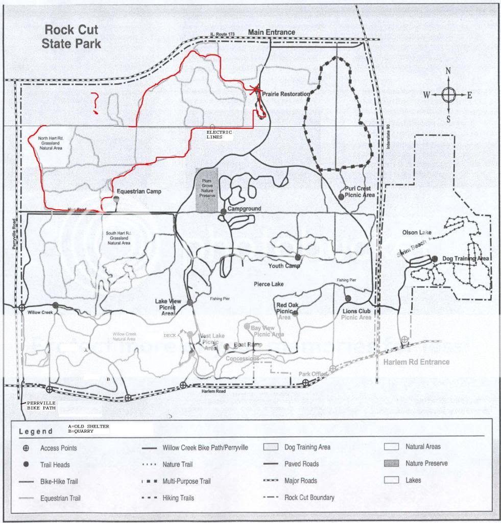
According to my GPS trip computer, 4.3 miles. The GPS track log says it was 5.3. I am betting the trip computer is closer. But no way for me to know for sure. The topo map is just plain wrong through. Perryville Road is pretty much straight north and south, not curved in as is shown on the map. I never crossed over Perryville, although I did go right along side it. At one point I was maybe 20 or 30 feet away and about 30 feet above it. I could have just walked down the embankment to the road. The topo map shows the park extending to the west of Perryville, but it actually just stops at the edge of Perryville.

The roads shown inside the park on the topo map are incomplete. We parked by the route 173 entrance (West Lane Road on the map). There is a north south road through the park that is just missing altogether from the map.

On the bright side. It was a nice day out and we had a nice hike. I had never hiked in this section of the park before. The trail we took into the wooded area in the NW corner of the park is not on the trail map, but it is clearly well used. A great forest path.

We saw 5 turkeys in the horse camp area, and saw turkey prints in the mud while walking on the trail.

At one point in the video I think I make a statement that while there is a lot of elevation changes that I dd not think the highest spot was more than 100 feet above the lowest spot where we hiked. Th GPS log says the low spot was about 720 feet, and the high about 850. I was not real far off.

Sunday, March 13, 2011

kinnikinnick creek conservation area 3-13-11

ETA: Our last visit here

Somehow I lost a couple of the clips along the way, including the one where I talked about the conservation district employee I met along the trail who was scouting for horse users. They are not allowed this time of year because they damage the trails severely. So some of my comments won't make much sense as they refer to a clip that does not exist.

I really wanted to try out the trail along the south side of the creek that we finally found at the very end. The employee said it was not an official trail, just where people have walked to get to the creek a lot over the years.

2.64 miles according to GPS, about 2 and a half hours. I believe the distance. The trail map says the horse trail is 3.5 miles and we did not go that far. A lot of time was wasted bushwhacking it. Very slow going some of the time. I doubt the route we took would even be passable in the summer once stuff started growing.

Oddly, the GPS track log says it was 3.2 miles. I am inclined to believe the smaller number, based on the stated length of the horse trail as being 3.5 miles. We were well inside the horse trail virtually all the time and basically walked around in a smaller rectangle than the horse trail.

We had a good time, mud and all.


[added 3-20-11]
It's a rainy and gloomy day, so the hike in the woods with the beagle has been delayed, or maybe canceled. It is thundering and raining pretty hard. So I decided to play with the GPS my wife got me for Xmas. I have not had a lot of time to work with it. 60+ hours a week of work plus the rest of life tends to do that to one. But over time I have learned to use bits and pieces of it. I even found a place that has free topo maps I can use.

I turned the tracking feature on but with the default map (such as it is) that the Garmin eTrex Vista H comes with, it is not real useful. The addition of the topo map makes it a whole lot more usable. I printed out a track of last Sunday's hike and put it on my blog along with the sketch I made from memory afterward. They are pretty close, except for the part where I put a question mark in the sketch because I was unsure exactly how I got from one point to another.

I am a little disappointed that the topo map does not have the roads inside this particular preserve as part of the map. Nor does it show the boundaries of the preserve. But, it is free, and works pretty well.

Now that I have a map loaded that actually has some detail in it, it might be useful for navigating in the woods. It takes some effort for me to work with the tiny screen so it may be a while before it is useful to me for navigating in the woods.

Sunday, March 6, 2011

colored sands forest preserve 3-6-11

A nice hike. Nothing special. But it's always good to get out and wander around in the great outdoors.

Colored sands is across the street from the FP we hiked last Sunday. The main trail loop is only 2 mile long. We could have gone off on some side trails but the snow on the lesser trails discouraged me from doing so. 2.17 miles according to GPS. 92 minutes. A lot of the trail had snow on it and was a bit slow, but most of it was OK.

We did stop to chat in the parking lot with some people we ran across last week and some other people who were taking pictures. They took pictures of us. Wilma is just so photogenic.

Getting to these FPs is a bit of a trick. They are out in the middle of nowhere. It's not hard to get there, but Google maps is not all that much help as the area is not real well mapped.

Take Rockton Road west from Rockton, IL. It changes names to Shirland Road along the way. In Shirland at the school, turn north on Boswell Road. There is a sign there telling you to turn north to get to Sugar River FP. Nothing said about either Colored Sands or Sugar River Alder FP. But that is how you get to them too.

You will pass Forest Preserve Road as you head north on Boswell. There is a sign there telling you to go west (left) to get to Sugar River FP. Keep going north. Go north to Yale Bridge Road (the next road). Turn west (left) and go to Hauley Road (not far - I think it is the next road), and turn north onto Hauley. Haas is the first cross street. There is a sign there telling you to turn left (west) to get to Sugar River and Colored Sands FPs. Turn onto Haas Road. There is a sign right there saying no outlet. Google maps shows Haas Road as continuing north through the park and going up toward Wisconsin, but it does not actually seem to do so.

Sugar River Alder FP sneaks right up on you. It would be real easy to drive right past it. Colored Sands is across the street. I parked at Sugar River Alder and walked across the street into Colored Sands to start our hike. The parking lot at Colored Sands half a mile or so down the road was locked up so I ended up coming back and parking at Sugar River Alder FP.

I have been told you can walk along the Sugar River from Colored Sands FP down into Sugar River FP to the south. There is no trail shown on the map going that way and I did not try it. Maybe some time after the snow melts we will give it a try.

The trail map shows a segment of the main trail loop going along the north edge of the FP just inside the FP along Haas Road. There was sort of a trail but the bird nets were up along it and there was a sign saying the area was closed. In any case it does not appear to go all the way to where we started across the street from Sugar River Alder FP so we just hoofed it along Haas Road back to where we started.