Last updated 11-21-15
Winnebago County Forest Preserve District website.
Some of the preserves are closed during firearms deer season. Best to check before showing up. Some times they post it on their web site, sometimes you have to ask. There is no actual hunting in the preserves except by district employees. It is one long weekend in November and another in December.
I recommend downloading and printing out a trail map if you plan on hiking in any of the preserves. Many have boxes for trail maps at the entrances but most of the boxes that I have looked in were empty. The trail maps are pretty good for what they cover. The trails tend to be pretty well marked, and many (but not all) of the preserves have trail maps posted out on the trails. Often the trail maps posted at the site are somewhat different than the trail maps you can download, in a few cases, substantially so.
All the ones we have hiked in also have unmarked trails that are not on the trail maps provided. I now realize many of these "trails" are actually firebreaks. The maps often promise numbered trail markers, but many of these markers just do not actually exist on the trails. In some cases there are numbered markers on the trails that are not reflected on the trail maps. The boundaries of the preserves we have hiked in are mostly well marked, which is good as the boundaries are often irregular and not real obvious, and there is a lot of private property that might otherwise appear to be part of the preserve.
The web site has a nice PDF covering the whole county with all their preserves well marked that is worth a look. You have to zoom in to see anything, but it is good for helping one find where the preserves are and orienting yourself a bit before heading out. The county wide map also has other parks shown as well so it is a good guide to the whole county. It does have at least one mistake as it shows a triangular sliver of district land connecting Rotary to Kishwaukee River FPs, but the little sliver of land is actually private and is posted that way on the ground.
Most of the preserves we have hiked (except as noted below) have hand pumps for drinking water and are noted on the trail maps. So far all have had usable outhouses, also on the maps. I have tried most of the pumps we have come across to get water for Wilma and so far all have worked with no more than a dozen pumps.
All the outhouses I have been in were a lot cleaner than one might expect of an outhouse. The floors tend to get wet when there is rain, but they are outhouses. The rain may help keep them clean for all I know. They seem to be replacing the old style wooden outhouses with fancy new plastic ones.
Some of these preserves do not seem to get much use. I have been in some where there are no cars in the parking lot and have often hiked for hours on the trails without running across anyone. Others seem to get more use.
Wilma likes to play in and drink out of the creeks and rivers, and many of the preserves feature water of some sort. In some cases there is easy access to the water, in others not so easy. A few have no water features.
I have emailed them several times with questions and maintenance issues. Replies have been kind of spotty to emails addressed to the general delivery email address. Might be best to just call. I have had several email exchanges with various staff members. Getting an actual person's email address rather than the general delivery email address seems to be the key to getting an answer by email. Not much different than most places.
There are several clusters of preserves located physically adjacent to each other which makes them in some respects effectively a much larger preserve.
In the NW corner of the county mostly along the east bank of the Sugar River there are three preserves. Sugar River Alder FP starts at the state line and goes south to Haas Road. Colored Sands FP starts at Haas Road and goes south to Yale Bridge Road. Sugar River extends south from Yale Bridge Road. There is easy foot access to SR Alder FP from CSFP, just walk across the street from the northeast side of the preserve. Easy foot access to Sugar River FP from the south side of CSFP. Getting from the north side of CSFP to Sugar River FP on foot involves some trails that are unmarked and not on the map. All these preserves include small amounts of property along the west bank of the river, and there are a lot of chunks of privately owned property along the east bank that are not FP property. On the other side of the state line in the far NW corner of SR Alder FP, is Avon Bottoms, a WIDNR property. I was able to get into AB on 11-24-11, but could not go more than a few hundred yards before being blocked by water. I have been told by a guy at the WIDNR that he was able to get to Alder from AB by walking over the water when it was frozen.
There is another cluster of preserves along the Kishwaukee River starting at the county line and going southwest along both sides of the river.
These are the preserves Wilma and I have hiked in.
Atwood Homestead Map
This is mostly a golf course but has a small section along the river that is a typical park area. It does not have much in the way of trails. Fran likes to drive though it now and then.
9-30-12 Drive through - 4 turkeys!
11-10-12 Drive through - Wilma in the river
3-30-14 We finally walk around in here - turkeys!
7-12-14 Pelicans
8-22-15 Drive through - baby turkeys
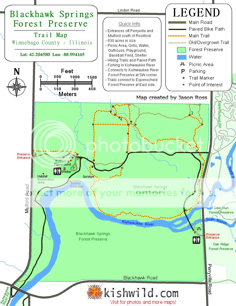
Blackhawk Springs. MAP KISHWILD.COM MAP
A good sized preserve. No horse trails. Has a natural spring. The main trail loop follows the bank of the Kishwaukee River for the better part of a mile. A foot trail connects to Espensheid FP. The paved Kishwaukee Recreational Path connects to Kishwaukee River FP to the south on the west side of the river, and to Oak Ridge FP via a bridge in the SE corner of the preserve that you can get to by taking the paved trail out to Perryville Road and walking across the road, and south a short distance.
9-18-10 Hike
4-14-12 Hike
4-21-12 Hike
3-30-14 Walk along the bike path - bald eagle
Clayton Andrews
Smallish preserve located in the middle of Roscoe. No where to park near the official entrance to the north so best to park on the south end. No facilities. Read my 11-25-12 hiking report for additional information.
11-25-12
Colored Sands. MAP
Medium sized. There are some benches located along the main trail loop. Lots of grade change on the main trail loop here, but it is only a 2 mile loop. There is a bluff above the river worth taking a look at. You have to take a side trail to get there. It is labeled as Sand Bluff on the trail map. The trail map shows the main trail loop as crossing the full length of the preserve along the north edge, but it really doesn't go the whole way. You have to go out to the road for part of it. When the bird nets are up even the partial trail along the road is not usable. I have taken to just walking along the road for this segment. Lots of birds and wild flowers. An unlabeled but well defined trail not shown on the park map takes you from the main trail loop to the south side of the park. I have parked at Sugar River Alder FP a few times and just walked across the street to Colored Sands to start my hike. There are a lot of unmarked trails in the fields that are not on the trail map.
3-6-11
11-6-11
9-15-12
12-28-13
County Line MAP
This FP is closed at present as there is no access to it until the bridge work on I39 is completed. Sometime late in 2014 is the present schedule for reopening.
This one has to be accessed in Boone County. Not a bad hike (about 4 miles round trip). Easy trails. Has a fancy new outhouse at the trail head which is located on a Boone County Conservation District property. You have to walk about a mile through a BCCD property to get to County Line. No well. You can hike back through several BCCD properties.
11-20-11 We just stopped by here today to take a look.
11-21-11
11-30-12
Deer Run. Map Kishwild.com Map
Good sized. Horse trails. Lots of water but except at the horse crossings into Oak Ridge FP not much access to it on the south end of the park. Lots of nice trails. The horse ford between Deer Run and Oak Ridge was too deep for me to ford without getting wet feet when we were there, but there are some places one might be able to cross, depending on the water level. There is a canoe launch near the parking area along the river not shown on the park map. The pump here has been removed.
9-25-10
11-13-11
9-23-12
5-12-13
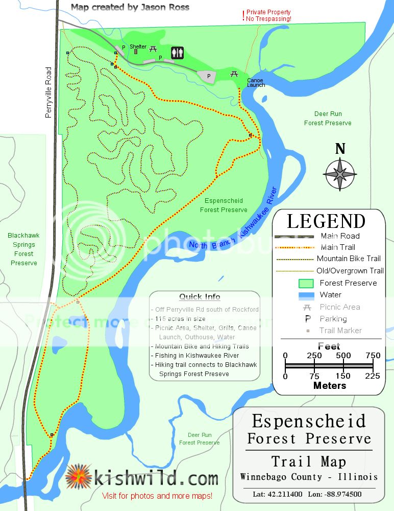
Espenscheid. DistrictMap BikeClubMap
Smaller. Not much in the way of trails but the trail system connects into Blackhawk Springs. The trails such as they are are kind of hilly so they are a good workout. There is also a bike trail that go around in winding paths that were fun to explore, but easy to get turned around on.The FPD web site claims the facility is 114.7 acres rather than the 60 acres the trail map claims. It seems bigger than 60 acres to me. I emailed the FPD and they confirmed it is only 60 acres. At one time there was additional acres across the river that made the total 114 acres, but the part across the river is now part of Deer Run FP. The district map does not show the 3 mile long bike trail, but I found one on the web site of a local bike club.
10-17-10
4-14-12
12-27-12 Diabolical Mountain Bike Trail
Four Lakes Map GoogleEarthImage
Mostly a fishing area. Has four fishing "lakes" (really ponds) and a dog training area. The trail map shows some kind of a path around the lakes. Not long ago they added a couple more ponds that belonged to the former sheriff that is to the west of the existing ponds. The trail map does not do the place justice. We walked 3.3 miles on trails, walkways between ponds, and fire breaks, and did not even walk all of them.
3-25-12 Dog Training Area Scouting Trip
12-14-12 Hike
Fuller. Map.
Medium sized. Basically a couple of loops around and through some weed fields. Just under 3 miles of trails.
10-15-10
9-16-12
1-19-13
Hartley Memorial Forest Preserve
A small property just south of Durand on route 70. No actual trails, although there is a sign and two parking spaces. That is it as far as facilities go. It is a typical hardwood forest so it is open enough at ground level to get around in.
11-21-12
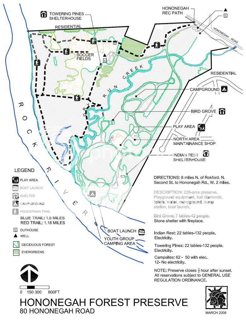
Hononegah. Map.
Medium sized. Sits along the Hononegah Recreational Path. Has a nice creek for Wilma and Rock River frontage. Short trail system, maybe 2.5 miles total. A hike can be extended by crossing the creek on the convenient foot bridge provided and walking along the roads through the east side of the forest preserve.
9-9-10
2-5-12
2-18-12
3-10-12
10-02-12 Drive through
10-28-12
12-23-12
1-17-15
HQ.
Small. There is a paved bike path (part of, or an extension of, the river front path) around an old quarry full of water on the west side of this facility. The east side is worth going to. Not much of a trail system, and what there is is poorly marked and washed out but it is kind of neat to poke around in the swampy area along the river. It won't take long but it is worth taking a look at.
10-10-10
3-3-13
3-15-14
Indian Hill.
Another small facility. But worthy of a look.
10-30-10
J. Norman Jensen Map
A smallish facility with a short (< 1 mile) trail that may have been a dirt road at one time. The trail loops around from the parking lot down along the Rock River. It is one of the nicer sections of the Rock River, and quite scenic. The map refers to something called an overlook. It is a nice look over the river. There are some stairs at the overlook that go down a steep bank to the river. There appears to be a short path segment along the river for fishing access. There is a brick oven standing next to the trail - no structure in evidence such as a cabin - just the oven. Worth going to, even with the short trail. No well. I am told you can get to the Rockton Dam as it is adjacent to this property. The trail does not go there directly though. I have not tried getting to the dam yet.
2-27-11 It was not open when we went by
8-19-12 It appears to be open now
9-2-12 We finally hike it
11-3-12
11-10-13
12-7-14
Keiselberg Map
A medium sized facility. There is a creek in the NW corner of the facility, but it is not real easy to get to. Benches are conveniently located along the trails. The trails are sometimes along the edges of the park and within 10-20 feet of backyards of houses. The big draw here is the model airplane flying field. There are also some soccer fields.
9-12-10
2-26-12
1-26-13
12-27-13
12-23-14
Kilbuck Bluffs
Not much in the way of trails but a great view.
11-22-11
Kishwaukee Gorge North
A smallish to medium size facility. Very steep terrain to get down the side of the hill to the river. Just as steep going back up. There are steps down to the river. Lots of steps. Maybe 75 or 100. Not much in the way of trails but worth a trip. The overlooks are basically small wooden decks. Can't see much when the trees have leaves. I bet the view is pretty decent after the leaves fall off.
10-1-11
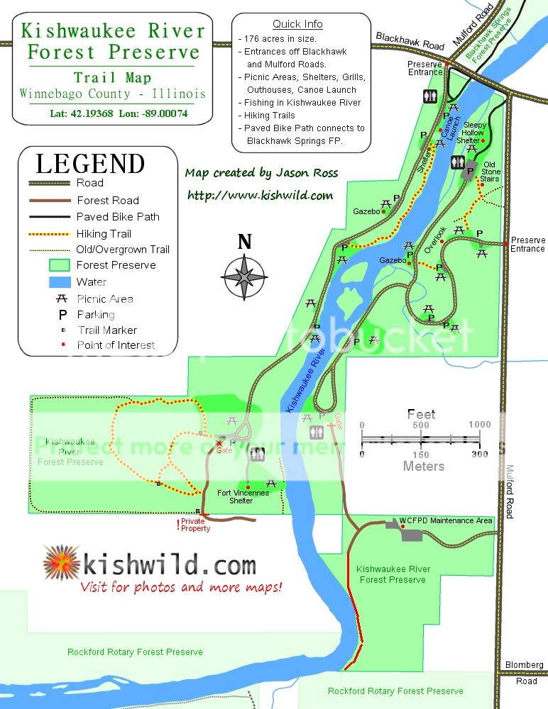
Kishwaukee River FP Map Kishwild.com Map
This is one of the district's older facilities (1927). It does not look like much of a hike from the district map, but it is a better hike than the map gives it credit for. The map leaves out some nice hiking. The better map I got from Kishwild.com shows more trails. Take a look at the 4-14-13 post for more information.
12-11-11 East Side of River Visit
4-14-13 Hike Both Sides
4-21-13 Flood
Laona Heights FP
A small (40 acre) preserve. An older preserve according to the sign out front - 1924. Typical FP stuff - outhouses, well, picnic tables, shelter, play fields.
9-15-12 Visit
11-3-12 Hike
McKiski Map
This preserve is small but has a nice horse trail. It can only be accessed from Deer Run after about a 2 or 3 mile hike first so probably does not get a lot of foot traffic. Nothing there in the way of facilities - not even a sign to tell you when you have crossed from Deer Run into McKiski. Part of the trail is under the power lines and it is not always obvious where it is as it gets overgrown sometimes.
11-13-11
9-23-12
5-12-13
Millrace Isle
A medium sized facility with nothing in the way of facilities at present other than a single parking space. There is not even a sign or a trash can. It features a mixture of wooded areas, fields, and river bottom areas. Its a lot of work hiking in here. There are no trails although there is a fire break that extends along the west edge of the preserve and continues about half way along Rockton Road. Wilma and I walked along the perimeter of the whole preserve. The whole of the southern and western perimeter is the Rock River. There is an old rail line that has been removed that cuts the preserve in half that is a little hard to get past but not real awful. It will make a nice trail segment some day, although I have been told there is some kind of plan to remove it to use the dirt for a parking lot..
11-16-12
Oak Ridge
Good sized with lots of nice trails. Wilma especially appreciated all the access to the river, although the banks are fairly high in much of the preserve, there is a canoe launch and a couple places where she can get to the water.
10-3-10
10-6-12
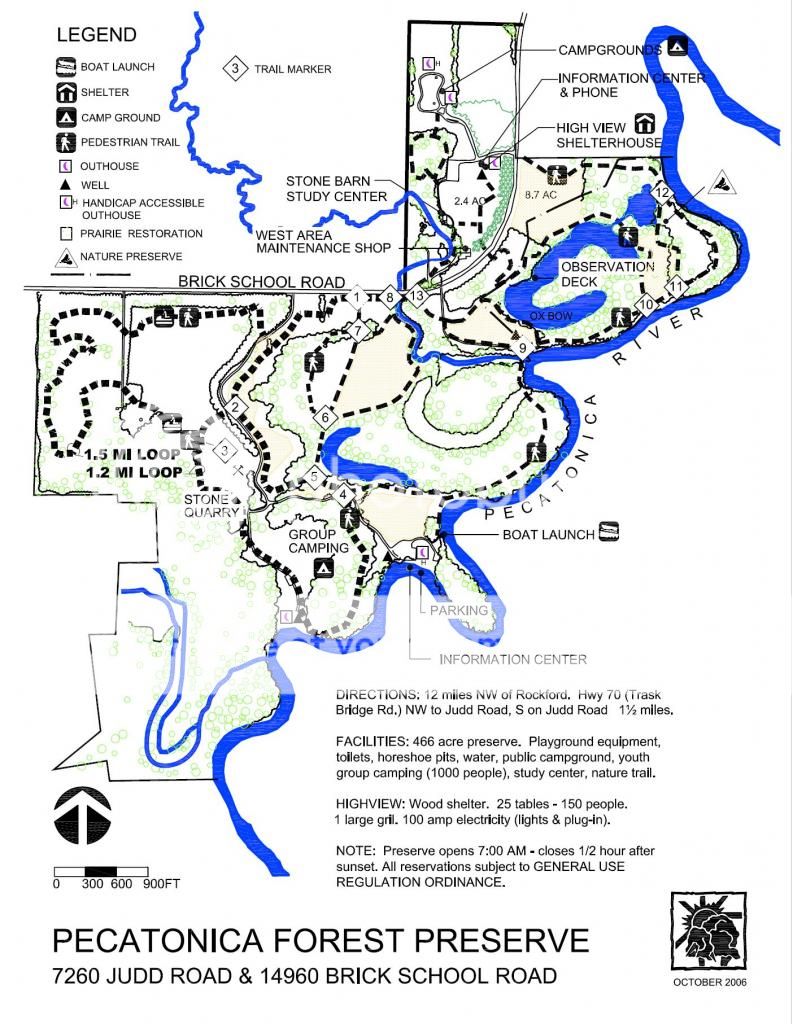
Pecatonica River Map
Nice sized. A lot of nice trails here in a good sized park with plenty of river access for Wilma.
10-29-11
3-24-12 Sadly, they have clear cut a very nice wooded area here too.
2-23-13 We tried to hike but did not get far
4-13-13 Wet!!!
Pecatonica Wetlands Map
Maybe the largest preserve. Lots of trails but not much access to the river for the beagle due to the steep and high banks on the part north of the river. The part south of the river that can only be accessed via the Pecatonica Prairie Path is pretty neat with plenty of water access for Wilma. The trail map implies there are several places you can cross creeks, but the crossings on the SE side of the park are just not there. The one shown on the SW side of the park labeled "low water crossing" could indeed be crossed during low water times or if you had tall enough boots or did not care if you got wet feet. There are no facilities on the part along the Pecatonica Prairie Path, although there is an actual bathroom at Sumner Park in Pecatonica where we park to get on the PPP.
9-26-10
3-25-12
4-21-12
11-19-12
02-17-13
03-30-13
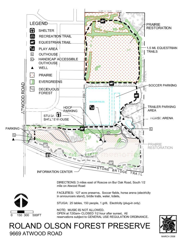
Roland Olson Map
A nice hike. All horse trails, but mostly even and level. There is an odd note on the trail map banning music. The Stone Bridge Trail runs along its southern border. The Long Prairie Trail connects to the Stone Bridge Trail across the street from the far SE corner of the park.
12-7-11
12-12-11 We pass by while on the Stone Bridge Trail
12-24-11 They posted a sign saying they are cutting down the pine trees there
3-4-12 They cut down most of the pine trees - ugly
11-10-12 Rain shortened hike
02-09-13 Slushy Snow
12-01-13
2-12-14 Post that mentions a horse trail between Roland Olsen FP and KCCA
12-24-14
Rockford Rotary Map Kishwild.com Map
Nice forested area along the river. Only a couple of miles of trails. Lots of grade change. I think there would be some opportunity for exploration here.
12-11-11
5-5-13
Seward Bluff
A sentimental favorite as my family used to camp here 40 some years ago. Lots of creek access. Considerable grade change. Great scenery, especially in the fall. Varied terrain. Nice well marked horse trails. There is a bridge across the creek at the far west end of the preserve so you can cross to the other side that is not shown on the map. The district web site alludes to some kind of plan to add a trail under route 20 to get to Grove Creek FP on the north side of route 20.
11-6-10
12-28-11
11-24-12
Sugar River
A nice sized preserve. Nice horse trails. I saw deer and turkeys the first two times we were here and a great blue heron the first time.
11-14-10
11-6-11
8-19-12
11-11-12 We get half a dozen deer on video
Sugar River Alder Map
Access to Avon Bottoms if you are adventurous. Good sized park with a nice set of trails. Access to the river is tough. There is a creek of sorts up on the north end that Wilma appreciates. A picnic table, well, and pit toilet on the north side at the old entrance. Lots of grade change.
2-27-11 Snow
11-5-11
11-23-11 Avon Bottoms
9-8-12
12-31-12
6-30-13 Flooded Trails
Trask Bridge
This is a small facility, 15 acres according to the trail map. It has a boat launch, picnic facilities, and fishing access to the Pecatonica River. No actual trails.
3-25-12 We stop in as we passed by going to another FP in the area.
11-21-12
Two Rivers Map GoogleEarthImage
This is a long (0.6 miles) skinny (20-75 feet) preserve located along the west bank of the Pecatonica River stretching from Freeport Road (Route 75) up to the Sugar River. It is located entirely between Harrison Road on the west side and the Pecatonica River on the east. It has the usual preserve amenities - a pit toilet, well, picnic shelter, picnic tables, grills, and fire rings, along with a boat launch. Not much as hikes go, as you have to walk either along the road or the bank and they are only a few feet apart. But Wilma got to play in two rivers and we had a nice riverside walk here.
12-14-12
Preserves we have been to but not hiked.
Crooked River Location
This preserve is mostly tall grass prairie that frequently floods. It is an excellent waterfowl habitat. It is well suited for fishing along the banks of the Pecatonica River [web site description]. It is across the street from Pecatonica Wetlands on Pecatonica Road. Mot much there beyond a sign, three picnic tables, and a few parking spaces. The district does not have a map of the place on their web site, although the outline of the property is shown on their countywide map.
2-17-13
Hinchcliff
Basically just a canoe launch. I am not even sure there is access to it at present due to bridge work being done to the adjacent bridge.
11-22-11
Severson Dells FP
NOTE: Severson Dells does not allow dogs.
A good sized facility with a creek. Wilma is not allowed here, so we have not hiked in this FP. We did drive through one day when we were in the area.
9-16-12
Stone Bridge FP
12-7-11 It is a long way from being ready for the public right now.
12-12-11 We pass by while on the Stone Bridge Trail
Trailside
Not much here but some picnic tables. You can see a picture of the entrance sign in this post. It is the very last picture.
10-30-10
Preserves we have not been to.
(Descriptions from the district web site)
Carl and Lois Klehm Forest Preserve is the site of a world class arboretum and botanic garden. The Klehm Arboretum and Botanic Garden operates many educational programs and events for the public throughout the year. Attractions include a botanical education center, a children’s garden, fountains and a wide variety of native and exotic trees and plants. [we probably won't go here as they charge $6 to get in - they do allow dogs though]
GROVE CREEK
Acres: 80.5
Hiking Trails: No – Seeking permission for trail under U.S. Hwy 20 to connect with Seward Bluffs
Kishwaukee Gorge South
Public access is provided from the private Faust Lane off Rotary Road. This 49.6-acre preserve is currently undeveloped.
Ledges
Scenic and challenging 18-hole golf course. [I don't play golf and I don't think there is anything else there]
Macktown Forest Preserve is comprised of a golf course and a historic site, which total 280.8 acres of wooded land along the Rock River. Macktown offers a shelterhouse and an education center. The education center and historic settlement are programmed by the Macktown Living History Education Center. [This FP is across the river from Mill Race Isle FP]
 /
/ /
/
No comments:
Post a Comment